Water scarcity report - 02 October 2025
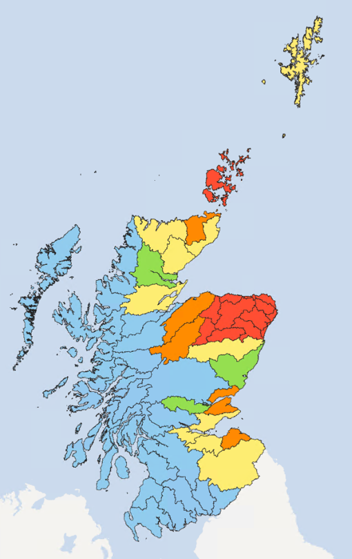
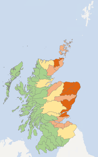
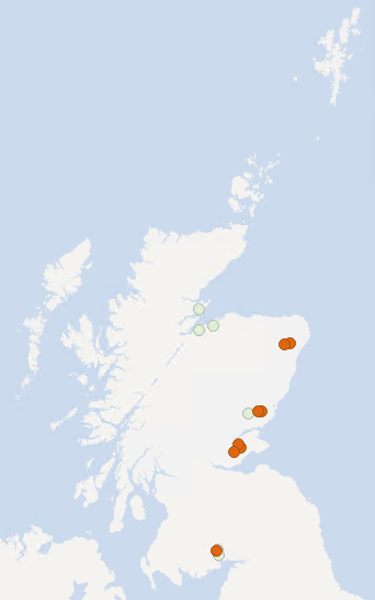
The River Avon, Lower Spey, Deveron, Ythan, South Ugie Water, Upper and Lower Don (Aberdeenshire), and Orkney remain at Significant Water Scarcity.
The rest of the Spey, as well as the Findhorn, Firth of Tay, Tyne (Lothian) and Thurso catchments remain at Moderate Water Scarcity.
The Esk (Angus) has recovered from Alert, joining the Shin and Earn at Early Warning.
The Conon, Dee (Aberdeen), Wick, Helmsdale, Firth of Forth, Almond, Tweed and Shetland remain at Alert.
The Ness has recovered to Normal conditions, joining the rest of the country.
Situation summary
Orkney, the River Avon, Lower Spey, Deveron, Ythan, South Ugie Water, and the Upper and Lower Don (Aberdeenshire) catchments remain at Significant Water Scarcity due to continued low flows. Rainfall in September remained below average across these areas, extending a longer-term deficit. For example, the lower Spey has had below average rainfall for every month of 2025.
SEPA have issued temporary restrictions on some licences to abstract water from the environment in the areas that have reached significant water scarcity. For further information visit Significant water scarcity guidance. While rainfall is forecast over the next few days associated with Storm Amy, it is not yet clear whether this will be enough to see rivers recover to lift restrictions.
The rest of the Spey remains at Moderate Scarcity, as well as the Findhorn, Firth of Tay, Tyne (Lothian) and Thurso. The Conon, Dee (Aberdeen), Wick, Helmsdale, Firth of Forth, Almond, Tweed and Shetland remain at Alert, however the Esk (Angus) has seen some recovery due to recent rainfall and now joins the Shin and Earn at Early Warning.
Further recovery in the Ness catchment means it is now at Normal conditions.
What do the map colours mean?
| Normal conditions | Early warning | Alert | Moderate scarcity | Significant scarcity |
|---|---|---|---|---|
| Blue | Green | Yellow | Orange | Red |
Water scarcity area descriptions
Weather Forecast
Outbreaks of heavy rain on Thursday, clearing for a time early Friday. Further rain sweeping through later on Friday in association with Storm Amy. Showers or longer outbreaks of rain on Saturday, Sunday and Monday, heaviest and most persistent in the west and northwest.
Advice for water users
Farmers and businesses in parts of eastern Scotland are facing water scarcity restrictions following prolonged dry weather that has caused areas to reach Significant Water Scarcity. For further information visit Significant water scarcity guidance and Advice for abstractors and irrigators.
Supporting information
This section goes into more detail on the data behind the water scarcity levels.
Rainfall and river flows
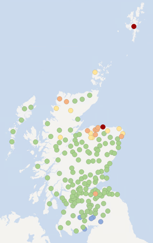
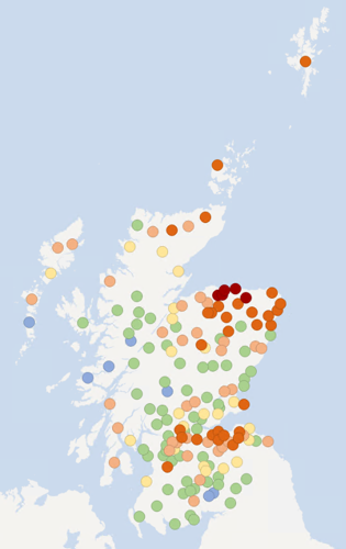
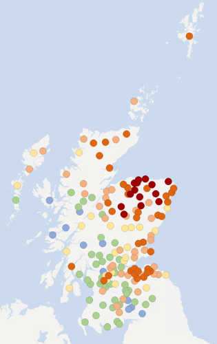
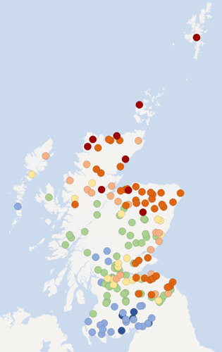
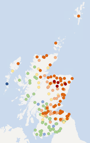
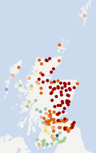
These maps show rainfall and river flows relative to the long-term average, for this time of year, over 1 month, 3 months, and 6 months.
Much of the country shows normal conditions for the 30-day average rainfall, with wet conditions in parts of southwest Scotland. In Shetland, the north and northeast however, conditions remain quite dry to extremely dry. River flows in the north and east of Scotland are generally low to extremely low, while in the southwest flows are largely normal to high.
Rainfall conditions over the last three months have generally been quite dry to extremely dry across much of the north, northeast, Outer Hebrides and central Scotland. Conditions are more mixed elsewhere, with much of the south and west of the country showing dry to wet conditions. River flows display an east-west split, with low to extremely low flows in much of the east and normal to very high flows in the west.
Over the last six months, the east of Scotland has been mainly dry to very dry, with extremely dry conditions prevalent in the northeast. Western Scotland has experienced more normal rainfall conditions while in central areas, conditions have been more mixed, with normal to very dry conditions. River flows across the east of the country have generally been extremely low while river flows in central Scotland have largely been very low. River flows are more mixed in the west and southwest, ranging from very low to high.
What do the map colours mean?
| Rainfall | Extremely dry | Very dry | Dry | Quite dry | Normal conditions | Wet | Very wet |
|---|---|---|---|---|---|---|---|
| River flow | Extremely low | Very low | Low | Quite low | Normal conditions | High | Very high |
| Red | Orange | Light orange | Yellow | Green | Light blue | Dark blue |
Soil moisture deficit
This map shows this week’s soil moisture deficit. This is obtained from the Met Office Rainfall and Evaporation Calculation System (MORECS). Ground conditions across much of the north and east of the country are generally quite dry to very dry, while western Scotland has no soil moisture deficit.
What do the map colours mean?
| Extremely dry | Very dry | Dry | Quite dry | No deficit |
|---|---|---|---|---|
| Red | Orange | Light orange | Yellow | Green |
Natural water storage – groundwater and loch levels
In each river catchment there is some degree of natural water storage, which can maintain river flows even when it is not raining. This natural water storage is mainly held in lochs and groundwater. When storage has been depleted it will take a lot of rainfall for levels to recover.
The maps below show recent groundwater and loch level compared to the long-term record at each individual station. Level is reported as high or low compared to the typical (‘normal’) level range for the time of year (August).
Level ranges are specific to each station and based on the long-term (minimum 10 years) record of mean monthly level values recorded at individual stations.
Despite the recent rainfall, due to the lack of recharge over the autumn and winter, groundwater levels across most of the country remain low to very low for the time of year.
A number of locations in Fife and Angus, and the Ythan catchment in Aberdeenshire, have recorded their lowest levels for August on record. In addition, Newton of Falkland in Fife and Murton Nature Reserve in Angus have recorded their lowest ever levels in their 28-year and 17-year records respectively.
Without significant rainfall, groundwater levels are expected to continue to fall over the autumn.
August average loch levels are low in the northeast of Scotland with levels elsewhere between normal and high.
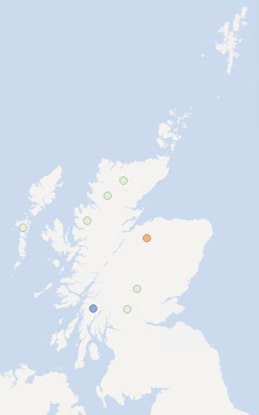
What do the map colours mean?
| Very high | High | Normal range | Low | Very low |
|---|---|---|---|---|
| Dark blue | Light blue | Light green | Light orange | Dark orange |
Flow, rainfall and groundwater data are accessed via SEPA's time series data service (API). SEPA's live data are subject to ongoing quality control and periodic review.
Scottish Water are responsible for public water supply and distribution in Scotland. Scottish Water reports on the raw water stored in these supplies.
Report copyright
- Current water scarcity levels - © SEPA. Some features of this information are based on digital spatial data licensed from the Centre for Ecology and Hydrology © NERC (CEH). Contains OS data © Crown copyright (and database right).
- Areas of significant water scarcity - OS Data - © Crown Copyright - SEPA licence number 100016991 (2022)
- Rainfall, river flow, groundwater and loch levels - Base map © OpenStreetMap contributors.
- Soil moisture deficit - Data based on MORECS (Met Office © Crown Copyright). Some features of this information are based on digital spatial data licensed from the Centre for Ecology and Hydrology © NERC (CEH). Contains OS data © Crown copyright (and database right). Base map © OpenStreetMap contributors.
- Weather forecast - Crown copyright [2022], Met Office